flikr
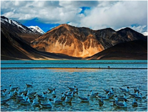
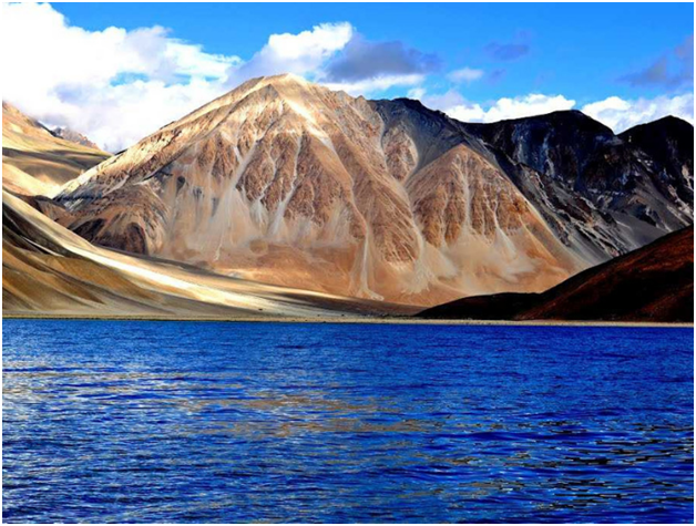
Pangong Tso Does Hanle
I woke up early around 6 am. The owner of the guest house was already awake and I joined him for a cup of tea. It was very windy and cloudy. The temperature must have been around 2-3 degrees at that time, I think. The view from the guest house was amazing. Pangong was within walking distance. I decided to face the cold morning and get to the lake.
That is what I received in return. Take a look. The photos came out a bit dull to this day as it was cloudy with much less light and does not do justice to the real beauty I witnessed.
Merak Does Chushul
Much has been written and discussed about the road from Merak to Chushul. It’s a total dirt track and sometimes you see a lot of tracks in front of you.
The guest house owner gave us a general rule. Drive along the lake for the next 10 kilometers. After that you will see a small bridge to the left. Do not cross this bridge as it goes to an army settlement. Keep right and follow the posts.
The information was true. Also, I would ask everyone to download Google maps offline, as they are 95% accurate.
The weather began to worsen as it began to snow in the hills.
Amazingly, the sky opened slightly when we arrived at Chushul, but only for 10 minutes. I was amazed at how quickly the weather changes here.
Flikr
Chushul Does Hanle
Chushul looked like a ghost town and found no one to ask for directions, as there were many trails passing through the village.
Finally, after a while, we managed to find some people. They directed us to a road. However, we did not find any Army checkpoints, as reported on most blogs. I think the track we were directed to must have passed the checkpoint.
Rezang la
It took another hour to get to the Rezang La Memorial, created in memory of the brave soldiers of the 13th Kumaon Regiment Battalion, deployed under the leadership of Major Shaitan Singh during the 1962 Indo-China War. You can read more about this in the article. of Vargis Khan, The Battle of Rezang La.
The road from Rezang La to Tsaga La seemed like an endless journey, traveling over gravel and loose rocks.
I think the bad weather out there has made it harder and duller for us. I heard a lot from everyone about the scenic beauty of this unit, but we were deprived of it due to clouds blocking the view.
We did not find anyone traveling on this stretch, as conditions were not favorable for the trip.
The date of this day was September 22. It was the same day that the Leh – Manali road was closed due to bad weather and many tourists were trapped in Pang, Sarchu and other places that were safely flown after 4-5 days. Night 22 also saw widespread rainfall in Himachal Pradesh, resulting in landslides and the cloud exploded in Manali, where Volvo buses were dragged.
The road was in poor condition and for the first time we witnessed a real water crossing before Tsaga La.
Flikr
Tsaga La
We soon approached the 14,500-foot Tsaga la with China on the left. You would find many army outposts on your left at the top of the mountains, which are checkpoints of the Indian army.
It had started to snow when we reached the gorge, so we decided to go down the other side. About 2 kilometers from the pass, we saw a small tea shop run by a local in a tent.
After Tsaga, you would start to find more vegetation. You will now be approaching the Loma curve, where you will witness the mighty Indus River, which is also the reason for all the vegetation in this area.
Finally, we found a paved road between Tsaga and Loma for the first time after Pangong.
Loma Bend
In about an hour we reached Loma Bend, where the road to Hanley forks. Loma is another place where licenses have been verified. It was a welcome surprise to see a lady running the post there. I talked to her and asked if we could go to Hanle. She said it was up to us to decide if we wanted to go as we had the permits. But looking at the cloudy sky, I informed her that we would jump Hanle and instead go to Tso Moriri. Everything she said “I think you made a right decision”

Flikr
Hanle Does Tso Moriri
I kept Hanle on my wish list to do so next time and headed toward Nyoma.
After crossing Loma, we saw different colors of the ground and mountains of red colors around. It was a magnificent view of that region near Nyoma. We had another stop in Nyoma for lunch and continued our journey towards Mahe Bridge, where we needed to turn left onto Tso Moriri.
This is where things got out of hand. ITBP and J&K police barricaded the road toward Tso Moriri. As we inquired, we discovered that there were orders from DC Leh and the Army not to allow anyone to venture on the Leh – Manali Road, as heavy snowstorms prevented traffic and weather forecasts were not good for the following night.
This was shocking to us as we had jumped Hanle to Tso Moriri. We tried to deceive them by stating that we had no intention of going to Debring and will return to this route after visiting Tso Moriri tomorrow. But they were in no mood to listen and showed us the way to Leh.
Tso Moriri Does Leh
After arguing for some time, we realized it was of no use. With a heavy heart, we drove on and took the Leh – Chumathang road. We were informed that the road via Chumathang was in good condition. Well, what to say. 90% of the road from Mahe Bridge to Upshi was under construction and in very poor condition.
The only photo we clicked on the way was from the hot springs in Chumathang.
We departed from Mahe Bridge around 15:00 and arrived in Upshi around 20:00, covering only about 120 kilometers. It was a difficult journey for all of us. The morale was also very low.
My Wagon R also suffered the first setback in this stretch. When we got to Upshi, the person in the driver’s seat could easily judge that the wheel alignment was out of shape. Prior to this track, we had traveled bad roads in the last 2 days with no problem.
After arriving at Upshi, we made a few phone calls at home to inform about our wellbeing. Everyone was really worried about the bad weather news.
After a cup of tea, it was time to find out where to stay the night; because the road from Upshi to Manali was also blocked by the ITBP.

flikr
The turn of events
After some discussion, we decided to seek Mr. Karma’s help again and called him. He was also worried about us and informed us to get to Choglamsar, where his sister runs a guest house called Potala Palace. It was raining a lot and we started driving towards Choglamsar. The 45-kilometer trip took another hour and a half.
By the time we got to the guest house, it was already 10pm.
Fortunately, Karma’s sister, the guesthouse owner was looking forward to us. She gave us the room that had a geyser that was already attached to us.
After refreshing, dinner was served to us shortly, as it was late. According to the owner, she had never seen such heavy rains in September for the past 16 years.
It was bedtime, for we were all tired, both physically and mentally from the unexpected turn of events. As we should realize the next morning, it continued to rain all night.
Itinerary Pangong – Hanle
There are two ways to get from Pangong Lake to Hanle, but it will depend entirely on where you were staying. Take a look at this Leh Ladakh region-wide roadmap to better understand what I’m talking about here. If you were staying in Spangmik, where most people and all the campsites are located, you can reach Hanle via the metal road via Harong and Erath or take the most scenic route through Man and Merak, but on a dirt trail. ; as we did in the travel journal. On both roads, however, you will exit Chushul and then follow Tsaga to reach Hanle.
There is also a third route that can be taken. By this route, after Chushul, you will take the road through Kaksang La and Horla to Mahe and then reach Hanle via Loma. But this is the hardest of all and really needs a high GC SUV with possibly a 4 × 4 unit.
Distance Pangong Lake to Hanle
If you follow the route Spangmik – Man Merak – Chushul – Tsaga – Loma; so the total distance from Pangong to Hanle would be about 160 kilometers; doable in about 6 to 7 hours. If you followed the Spangmik – Tangtse – Harong – Chushul – Tsaga – Loma route, the distance would increase to about 220 kilometers; But the travel time would decrease to about 5-6 hours due to the good way. If you took the road through Kaksang La, add another 50 kilometers to the two distances mentioned above.
flikr
Itinerary Pangong to Hanle
Pangong to Hanle is necessarily a day’s journey. An ideal itinerary is for you to arrive in Hanle, stay here all night and continue to Tso Moriri the next day. From Tso Moriri, you can drive back to Leh via Chumathang; or get off at Manali Leh route near Tso Kar and continue straight to Manali.
Itinerary Hanle – Tso Moriri
There are two routes from Hanle to Tso Moriri. The first is via Loma – Nyoma – Mahe and Sumdo. This is the most common route tourists are allowed to. From Hanle, you will travel 50 km back to Loma and then on to Sumdo via Nyoma and Mahe. From Sumdo, you will cross Namshang La to get to Karzok.
Hanle to Tso Moriri via Chumur
The second road from Hanle to Korzok (Tso Moriri) passes the Chumur route. From Hanle, you drive to Punguk and then take the road via Salsal La to Chumur. After Chumur, you will cross the Charchagan La Pass and arrive at Karzok. Note that Chumur is where most Chinese raids take place and is adjacent to the border. For safety reasons, tourists cannot travel on this road. This is a complete dirt track in most places, suitable for 4 × 4 vehicles only.
Distance Hanle to Tso Moriri
By conventional Nyoma – Mahe-Sumdo road, the distance between Hanle and Tso Moriri is about 150 kilometers. Via Chumur, this distance increases to about 180 kilometers.
Itinerary Tso Moriri – Leh
There are two routes you can take to get back to Leh from Tso Moriri. The shortest is via Chumathang and the longest is via Tso Kar.
Chumathang Route
Karzok (Tso Kar) – Namashang La – Sumdo – Mahe – Chumathang – Kiari – Upshi – Karu – Leh
Traveling this way, the total distance will be about 215 kilometers. The road between Karzok and Sumdo is bad, especially a dirt track. The entire route via Chumathang in our travel time was under construction and in very poor condition.
Tso Kar Route
The second route that can be taken from Lake Tso Moriri to Leh is via Tso Kar, as mentioned below.
Karzok (Tso Kar) – Namashang La – Sumdo – Kongka La Polo – Tso Kar – Debring – Tanglang La – Rumtse – Upshi – Karu – Leh
By this route, the total distance will increase to about 235 kilometers, but travel time can easily be around 8 hours due to bad roads. Karzok for Sumdo will be bad, Sumdo for Polo Kongka La will be extremely bad; Polo Kongka La to Tso Kar and then Leh will be a mix of good and bad. You will be crossing three high altitude passes traveling this way, with Tanglang La being the tallest.
Itinerary Tso Moriri to Leh
Tso Moriri to Leh is a journey of a few hours, unless you plan on spending a night in Tso Kar. An ideal itinerary, as I also mentioned earlier, would be to travel to Nubra from Leh. You can then continue to Pangong from Nubra via Shyok Road, continue to Hanle and then reach Karzok. From Karzok you can return to Leh or exit Manali Highway near Tso Kar and back to Manali. It will be a total of 5-6 journey days to complete the entire circuit.
Distance Tso Moriri to Leh
The distance between Tso Moriri and Leh will be between 200 and 235 kilometers; depending on the route you chose to follow. If you, however, traveled the other way around; this is to reach Karzok first and then cover Pangong on the way back to Leh; then the distance will increase to about 370 kilometers.
flikr
Comment (0)